• MTB trails
    of VALLESTURA di Demonte
  • Accommodation/Eat out
  • Contacts
  • MTB Valle Stura NEWS
  • Services
  • Who we are
MTB ValleStura
  • Home
  • Mtb Trails
    • Aisone
    • Argentera
    • Demonte
    • PietraPorzio
    • Saben
    • Sambuco
    • Vinadio
    • Vignolo
  • Services
  • Accommodation/Eat out
  • Who we are
  • Contacts
  • English
  • Italiano

M1 – Le Gravere

10 June 202010 June 2020, Demonte Mtb Trails
  • Prev
  • Next

M1 – Gravere

  • Departure/arrival location: Festiona (Centro Fondo)
  • Difficulty: Climb:OC Descent: OC+ Exposure: E3
  • Length: ????
  • Drop: + 1050 m
  • Departure altitude: 1225 m asl
  • Maximum altitude: 2223 m asl
  • Terrain type: 50% Gravel 25% trail 27% asphalt
  • Type of route: Ring route. Short round-trip on common road, easy route suitable for beginner bikers
  • Cartography: Fraternali Map 1: 25000 n° 13, Alta Valle Stura, E-BIKE, MTB Map

Description

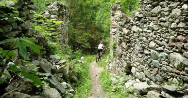
From the square in front of Centro Fondo area, we go towards the bottom of the valley following the signs for Borgate Rueita and Sottana, as soon as we cross the latter, we take an easy descent towards the plateau near the river, from here we continue on level ground on a gravel road with regular terraing until the beginning of a wildlife trail called “Le Gravere”. After crossing the latter on a trail that runs alongside the river, we arrive on the military road in San Membotto area of Moiola. From here we follow the military road keeping right towards Festiona until the indicated crossroad which makes us turn left onto a gravel road where, after crossing very suggestive chestnut woods, we descend first towards the military road and immediately after downhill to the beginning of “Le Gravere” wildlife trail. From here we return to Borgate Sottana and Rueita following the signs toward Centro Fondo on the same route as the first leg.

All the paths are frequented by hikers on foot, pay attention especially on descents: THE PEDESTRIAN ALWAYS HAS THE RIGHT OF WAY.

Posted in Demonte, Mtb Trails
MTBAdmin
  • Facebook
  • Twitter
  • Google Plus
  • Pinterest

Post navigation

B13 – ANTENNE ENDURO   

You may also like

A1 – FORTE DI NEGHINO

Continue Reading

A2 – COLLE DI NERAISSA

Continue Reading

PLEASE NOTE

No liability is accepted for damages and\or accidents to people and\or things on the trails indicated on this site.

PRATICABLE TRAILS

Check which trail is accessible at the moment!

No post found

Follow us

1 Vallata La magnifica Valle Stura
10 Comuni in provincia di Cuneo
41 Percorsi MTB Provali tutti!!
Tante strutture ricettive Bike friendly

© ASD ValleSturaSport - Demonte (CN) | Web by GigiWork
Questo sito utilizza i cookies, navigando accetti l'utilizzo dei cookies da parte nostra OK Ulteriori info
Privacy & Cookies Policy

Privacy Overview

This website uses cookies to improve your experience while you navigate through the website. Out of these, the cookies that are categorized as necessary are stored on your browser as they are essential for the working of basic functionalities of the website. We also use third-party cookies that help us analyze and understand how you use this website. These cookies will be stored in your browser only with your consent. You also have the option to opt-out of these cookies. But opting out of some of these cookies may affect your browsing experience.
Necessary
Always Enabled
Necessary cookies are absolutely essential for the website to function properly. This category only includes cookies that ensures basic functionalities and security features of the website. These cookies do not store any personal information.
Non-necessary
Any cookies that may not be particularly necessary for the website to function and is used specifically to collect user personal data via analytics, ads, other embedded contents are termed as non-necessary cookies. It is mandatory to procure user consent prior to running these cookies on your website.
SAVE & ACCEPT